Toggle navigation
Home
Article Category
Question Papers
General Knowlege
Popular Pages
Multiple Choice Question in 049
Multiple Choice Question in
Multiple Choice Question in TRADES-INSTRUCTOR---GR-II---SMITHY---TECHNICAL-EDUCATION
Multiple Choice Question in -current-affairs-2016
Question Answer in ASSISTANT-PROFESSOR---COMPUTER-SCIENCE-AND-ENGINEERING---TECHNICAL-EDUCATION
Multiple Choice Question in ASSISTANT-PROFESSOR---COMPUTER-SCIENCE-AND-ENGINEERING---TECHNICAL-EDUCATION
Multiple Choice Question in english
Multiple Choice Question in abbreviations-abbreviations-m
Multiple Choice Question in SSC CHSL 7 March 2018 Morning Shift
Multiple Choice Question in 2016
Multiple Choice Question in 072/2016
Question Answer Bank
Multiple Choice Question Bank
Question Answer Category
Multiple Choice Question Category
Home
->
Multiple Choice Questions
1. __________C.I. cover provided for manholes constructed within width of road under vechicular traffic.
(A): Light duty
(B): Medium duty
(C): Heavy duty
(D): None ofthese
Previous Question
Show Answer
Next Question
Add Tags
Report Error
Show Marks
Write Comment
Type in
(Press Ctrl+g to toggle between English and the chosen language)
Post reply
Comments
Tags
kerala-psc
TRADESMAN---PLUMBING---TECHNICAL-EDUCATIONPLUMBER
147/2016
Show Similar Question And Answers
QA->Traffic will be ____ through the side streets while the main road is resurfaced....
QA->World Day of Remembrance for Road Traffic Victims[WHO]....
QA->What isthe theme of World Day of Remembrance for Road Traffic Victims 2016?....
QA->The ratio of the width to the length of our national flag is:....
QA->WHAT IS THE RATIO OF WIDTH OF INDIAN NATIONAL FLAG TO ITS LENGTH....
MCQ->__________C.I. cover provided for manholes constructed within width of road under vechicular traffic.....
MCQ->--------------I.Cover provided for manholes constructed within width of road under vechicular traffic?....
MCQ-> DIRECTIONS for the following three questions: Answer the questions on the basis of the information given below.A city has two perfectly circular and concentric ring roads, the outer ring road (OR) being twice as long as the inner ring road (IR). There are also four (straight line) chord roads from E1, the east end point of OR to N2, the north end point of IR; from N1, the north end point of OR to W2, the west end point of IR; from W1, the west end point of OR, to S2, the south end point of IR; and from S1 the south end point of OR to E2, the east end point of IR. Traffic moves at a constant speed of $$30\pi$$ km/hr on the OR road, 20$$\pi$$ km/hr on the IR road, and 15$$\sqrt5$$ km/hr on all the chord roads.The ratio of the sum of the lengths of all chord roads to the length of the outer ring road is
....
MCQ->Event : (A) Recently the traffic jams on M G Road of city ‘Z’ are not reduced but the traffic has also become manageable. Event : (B) The flyover on MG Road of city ’Z’ has recently been made operational and the number of traffic police personnel has been increased.....
MCQ-> A significant amount of traffic flows from point S to point T in the one-way street network shown below. Points A, B, C, and D are junctions in the network, and the arrows mark the direction of traffic flow. The fuel cost in rupees for travelling along a street is indicated by the number adjacent to the arrow representing the street. –
Motorists traveling from point S to point T would obviously take the route for which the total cost of traveling is the minimum. If two or more routes have the same least travel cost, then motorists are indifferent between them. Hence, the traffic gets evenly distributed among all the least cost routes.The government can control the flow of traffic only by levying appropriate toll at each junction. For example, if a motorist takes the route S-A-T (using junction A alone), then the total cost of travel would be Rs 14 (i.e., Rs 9 + Rs 5) plus the toll charged at junction A.If the government wants to ensure that all motorists travelling from S to T pay the same amount (fuel costs and toll combined) regardless of the route they choose and the street from B to C is under repairs (and hence unusable), then a feasible set of toll charged (in rupees) at junctions A, B, C, and D respectively to achieve this goal is:
....
×
×
Type The Issue
×
Your Marks
Terms And Service:We do not guarantee the accuracy of available data ..We Provide Information On Public Data.. Please consult an expert before using this data for commercial or personal use
Powered By:Omega Web Solutions
© 2002-2017 Omega Education PVT LTD...
Privacy
|
Terms And Conditions
 Powered By:Omega Web Solutions
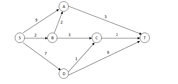 Motorists traveling from point S to point T would obviously take the route for which the total cost of traveling is the minimum. If two or more routes have the same least travel cost, then motorists are indifferent between them. Hence, the traffic gets evenly distributed among all the least cost routes.The government can control the flow of traffic only by levying appropriate toll at each junction. For example, if a motorist takes the route S-A-T (using junction A alone), then the total cost of travel would be Rs 14 (i.e., Rs 9 + Rs 5) plus the toll charged at junction A.If the government wants to ensure that all motorists travelling from S to T pay the same amount (fuel costs and toll combined) regardless of the route they choose and the street from B to C is under repairs (and hence unusable), then a feasible set of toll charged (in rupees) at junctions A, B, C, and D respectively to achieve this goal is: