Toggle navigation
Home
Article Category
Question Papers
General Knowlege
Popular Pages
Multiple Choice Question in 049
Multiple Choice Question in
Multiple Choice Question in TRADES-INSTRUCTOR---GR-II---SMITHY---TECHNICAL-EDUCATION
Multiple Choice Question in -current-affairs-2016
Question Answer in ASSISTANT-PROFESSOR---COMPUTER-SCIENCE-AND-ENGINEERING---TECHNICAL-EDUCATION
Multiple Choice Question in ASSISTANT-PROFESSOR---COMPUTER-SCIENCE-AND-ENGINEERING---TECHNICAL-EDUCATION
Multiple Choice Question in english
Multiple Choice Question in 2016
Multiple Choice Question in abbreviations-abbreviations-m
Multiple Choice Question in SSC CHSL 7 March 2018 Morning Shift
Multiple Choice Question in 072/2016
Question Answer Bank
Multiple Choice Question Bank
Question Answer Category
Multiple Choice Question Category
Home
->
Multiple Choice Questions
1. Each "1" entry in a K-map square represents:
(A): a HIGH for each input truth table condition that produces a HIGH output.
(B): a HIGH output on the truth table for all LOW input combinations.
(C): a LOW output for all possible HIGH input conditions.
Previous Question
Show Answer
Next Question
Add Tags
Report Error
Show Marks
Write Comment
Type in
(Press Ctrl+g to toggle between English and the chosen language)
Post reply
Comments
Tags
Show Similar Question And Answers
QA->Daily weather map showing isobars is an example of which map?....
QA->There are 50 students in a class. In a class test 22 students get 25 marks each, 18 students get 30 marks each. Each of the remaining gets 16 marks. The average mark of the whole class is :....
QA->If n represents the dimension of cube and k, the radix(no. of nodes along each dimensions. then the number of nodes N of a K-ary n –cube network is :....
QA->After passing journal entry we have to explain briefly the transaction for which the entry has been passed ______.....
QA->A Journal entry with more than one debit or credit is called _____ entry.....
MCQ->What will be the output of the program? TreeSet map = new TreeSet(); map.add("one"); map.add("two"); map.add("three"); map.add("four"); map.add("one"); Iterator it = map.iterator(); while (it.hasNext() ) { System.out.print( it.next() + " " ); }....
MCQ-> Study the following information carefully and answer the question given below:XYZ limited company organised an exhibition of machine tools. The exhibition was opened on all the weekdays for public. Certain passcodes were issued to the visitors as entry card. The passcode of entry card was changed every hour according to a certain rules as shown below. The entry time of the first batch was 7 PM. Each batch was allowed only one hour. The lunch time was from 1 PM. to 2 PM. Batch I(9 AM to 10 AM) Passcode: course easy set for each year was Batch II(10 AM to 11 AM) Passcode: easy each course for was set year Batch III(11 AM to 12 Noon) Passcode: each was easy for year course set and so on.If the passcode for the batch entering at 12 noon is ‘’she the girl is clever very good’’, then what will be the passcode for the batch entering at 3 PM ?
....
MCQ->
The passage below is accompanied by a set of six questions. Choose the best answer to each question.
Understanding where you are in the world is a basic survival skill, which is why we, like most species come hard-wired with specialised brain areas to create cognitive maps of our surroundings. Where humans are unique, though, with the possible exception of honeybees, is that we try to communicate this understanding of the world with others. We have a long history of doing this by drawing maps — the earliest versions yet discovered were scrawled on cave walls 14,000 years ago. Human cultures have been drawing them on stone tablets, papyrus, paper and now computer screens ever since.Given such a long history of human map-making, it is perhaps surprising that it is only within the last few hundred years that north has been consistently considered to be at the top. In fact, for much of human history, north almost never appeared at the top, according to Jerry Brotton, a map historian... "North was rarely put at the top for the simple fact that north is where darkness comes from," he says. "West is also very unlikely to be put at the top because west is where the sun disappears."Confusingly, early Chinese maps seem to buck this trend. But, Brotton, says, even though they did have compasses at the time, that isn't the reason that they placed north at the top. Early Chinese compasses were actually oriented to point south, which was considered to be more desirable than deepest darkest north. But in Chinese maps, the Emperor, who lived in the north of the country was always put at the top of the map, with everyone else, his loyal subjects, looking up towards him. "In Chinese culture the Emperor looks south because it's where the winds come from, it's a good direction. North is not very good but you are in a position of subjection to the emperor, so you look up to him," says Brotton.Given that each culture has a very different idea of who, or what, they should look up to it's perhaps not surprising that there is very little consistency in which way early maps pointed. In ancient Egyptian times the top of the world was east, the position of sunrise. Early Islamic maps favoured south at the top because most of the early Muslim cultures were north of Mecca, so they imagined looking up (south) towards it. Christian maps from the same era (called Mappa Mundi) put east at the top, towards the Garden of Eden and with Jerusalem in the centre.So when did everyone get together and decide that north was the top? It's tempting to put it down to European explorers like Christopher Columbus and Ferdinand Megellan, who were navigating by the North Star. But Brotton argues that these early explorers didn't think of the world like that at all. "When Columbus describes the world it is in accordance with east being at the top, he says. "Columbus says he is going towards paradise, so his mentality is from a medieval mappa mundi." We've got to remember, adds Brotton, that at the time, "no one knows what they are doing and where they are going."Which one of the following best describes what the passage is trying to do?
....
MCQ->In the following figure, square represents Philosophers, triangle represents Police officer, circle represents Pharmacists and rectangle represents Americans. Which set of letters represents Americans who are police officers?
....
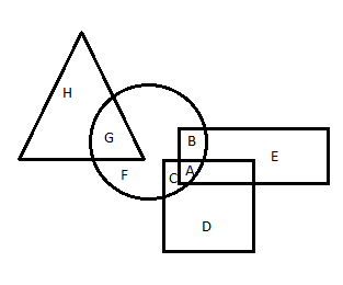
MCQ->In the following figure, square represents Artists, triangle represents Military officers, circle represents collectors and rectangle represents Fathers. Which set of letters represents collectors who are either military officers or fathers?
....
×
×
Type The Issue
×
Your Marks
Terms And Service:We do not guarantee the accuracy of available data ..We Provide Information On Public Data.. Please consult an expert before using this data for commercial or personal use
Powered By:Omega Web Solutions
© 2002-2017 Omega Education PVT LTD...
Privacy
|
Terms And Conditions
 Powered By:Omega Web Solutions
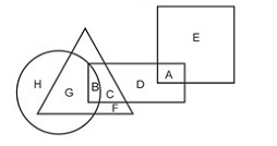 ....
.... ....
....